CSV. CAPTURING SOCIAL VALUE
Dynamic Urban Analysis Tool
CSv. Dynamic Urban Analysis Tool to create local policies. How to plan current complexity in cities? How to create dynamic tools for decision-making processes based on information obtained from the citizens?
Introduction
Current technology allows people to be permanently connected at a digital level, creating an enormous amount of data. While private entities use this information to improve their products and create new proposals based on user needs, cities have had more difficulties to create regulations and plans on par with the dynamism of contemporary events. The governance system of cities must evolve into a bottom-up design with inclusive policies based on social value and problems found at a local scale in urban life. The so-called Information Society should develop systems to transfer information in a transparent, immediate manner. Thus, citizen participation becomes a key factor for decentralization of decision-making and project implementation.
This phenomenon has led researchers to question the current model and propose a tool to develop policies considering the social value and specific conditions of a site. Collecting, classifying and visualizing data from a city population census and social networks such as Twitter, Airbnb, Foursquare and TripAdvisor in order to create dynamic simulations of the social conditions in the territory.
Methodology
This research is based on the analysis of consequences to land value increases, comparing conditions and policies used in various cities. We will develop and implement a tool able to evaluate the city of Barcelona by means of a diagnosis based on social indicators; with it, specific sites will be identified for the creation of local public policies considering citizen conditions. The main ideas will gradually lower in scale to promote a holistic understanding of the situation and the implementation reach for both the tool and the new policies.
1. CSv. LAND VALUE CONSEQUENCES
Historically speaking, how did the land value of any city increase? During most of urban development history, cities have created policies and landmark projects in order to improve quality of life and economy based on a top-down design. According to this design, the management would make the necessary decisions and implement projects without considering the social conditions of the area. However, this seemingly efficient vertical approach increased land value in areas where most services and money were located (centric city) and caused several movements in the middle and lower social classes, creating satellite cities more and more distant from the centric areas. This caused a series of social phenomena such as segregation, gentrification, insecurity and more.
From this global perspective, we can describe Land Value as: The value of a terrain or construction, estimated in accordance with its location, social-economic conditions, government regulations in force, context and access to services. Furthermore, we deem it an urban phenomenon which, without proper management, may result in inequality in the form of spatial and social divisions in the city.
.
2. CSv. CITY BENCHMARKING
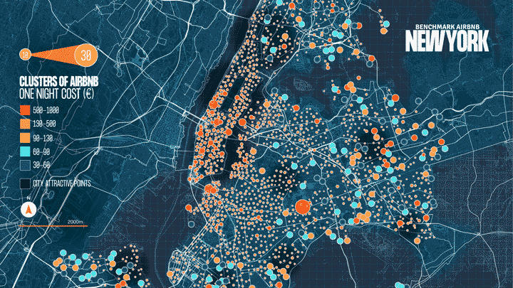
How have cities faced social inequality? After defining Land Value and understanding the negative consequences of this model worldwide, we propose a comparison between 4 cities: New York, Santiago, Amsterdam and Tokyo. Realities with opposite conditions for location, population density, area and economy but, in spite of this, with a common feature: they all have divisions in land value and a certain degree of inequality. This comparison includes two stages: first, the identification of the referential land value conditions using price-per-night data from the Airbnb platform to create a location density map in relation to the main urban landmarks in the city; and second, the assessment of city policies aimed to reduce inequality (segregation and gentrification). This helps the research project to understand “cause and effect” between policies and geospatial patterns.
City and local policies to face INEQUALITY
New York City: Zoning changes have had significant effects. In Brooklyn, 22000 new deluxe departments were built in 2019 while the offer of affordable housing for the middle and lower classes decreased considerably. The municipality ordered 515 census sections to be placed under a program of tax incentives for private investments in low-income urban areas. 53% of the sections are under risk of gentrification. Use of social housing incentives in strategic sites.
Santiago: Economic and industrial development prompted several projects around the Libertador Bernardo O'Higgins avenue which caused a clear increase in density and verticalization of residential buildings and brought the prices up by 53% over a span of only 5 years. The municipality provided a series of policies focused on plot acquisition in the central and northern areas (high income area) of the city for social housing projects. Right to the city. Increased equality in centric areas. Adaptable social housing.
Amsterdam: The city has seen constant movement from the middle and lower classes due to the great real estate speculation and attraction of tourists in the center of the city. The municipality plays a considerable role in the interventions of the property market by means of renewal and demolition of public housing, as well as the implementation of incentives for sale of social housing projects in all urban areas. The municipality as a key stakeholder in the real estate market. Management of a total model of social housing.
Tokyo: The city has been under constant evolution as property value is more linked to terrain than property itself. New buildings rarely last more than 30 years. Every year, the city creates around 100,000 new houses; a rate greater than population growth. The municipality has implemented mixed residence models where other elements such as commerce, labor and education may share space with residences in order to optimize buildable terrain use to the maximum. Optimization of land use and value. Mixed use residence programs.
.
3. CSv. BARCELONA DATA ANALYSIS
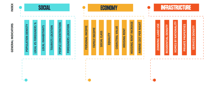
Taking the consequences of the actual system and the responses of various cities into account, we can define Social Value as: The feature valuation of inhabitants and their environment, estimated in accordance with their social, economic and infrastructural (indexes) conditions. These conditions were diagnosed by means of a series of indicators.
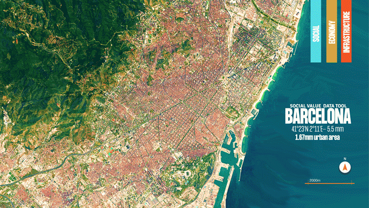
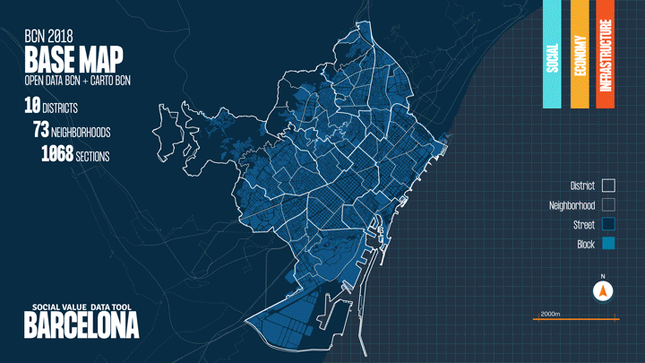
For this research, information from Open Data BCN and Spain's National Statistics Institute (INE) was collected, classified and visualized as well as sample data from the 2018 census of Barcelona. Data on the current situation of inhabitants generated on social media was considered as well. These datasets are represented in three different scales: districts, neighborhoods and census sections in the next 22 maps:
Current situation of Social Value in Barcelona:
Social: The indicators show how locals (Spanish-born people), foreigners (EU and externals) and tourists are distributed over the city. The center of the city contains most of the population density, stretching towards the East and West sides of the city with most locals living in the Northeast and Northwest; the foreign population is mainly located in the downtown area and the edges of the city, mostly in the central-South area in the Ciudad Vella district. In order to geo-locate clusters of tourists and settlements of foreigners, Airbnb and Twitter data was used; said data provides a dynamic view of their behavior and reveals that most clusters are found downtown, near the main historic landmarks.
Economic: Indicators show the economic situation of inhabitants, equality conditions, cadastral value and costs for housing and rent. Considering population income, the city can be divided in: Northwest, Center, and Southeast for people with higher income, Center-East and West for middle income and Northeast, East and Center-South for lower income. The segregation index is higher in poor neighborhoods where nearly 90% share the same social status. Cadastral value, housing costs and rent are related to the income division. Increased rent value ranges between 30% and 50% in the neighborhoods located in the center of the city (concentration of most landmarks and services) as well as those located Northeast (lower land costs). These areas display a gentrification phenomenon due to the real estate bubble of the last 4 years.
Infrastructure: Indicators show city zoning, housing density, intention in real-estate market, and accessibility to services such as transport, commerce, restaurants, etc. Land use in the coastal areas and the East and West edges is mostly dedicated to industry and port operations. The area with the highest housing density and highest rent opportunity is in the center of the city where most services and landmarks are located, and this area extends towards the Northeast where, given the low land value, there is constant real estate speculation with certain projects larger than 416 residences. For the citizen service study, over 50000 locations obtained from Foursquare and Tripadvisor were geo-located.
.
4. CSv. CAPTURING SOCIAL VALUE TOOL
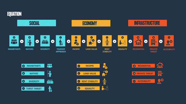
Capturing Social Value (CSv) is a dynamic tool which combines data sets in order to analyze social factors at various scales. Its main goal is to allow decision-makers to identify urgencies, create specific location policies and prioritize actions. Depending on the context and intention of use, CSV also allows users to personalize the weight of each factor.

CSv has 3 basic functions: First, to rationalize indicators and generate normalized factors on a scale of 1 to 10. Second, to generate and visualize scenarios by means of equations that combine and establish a hierarchy for the factors according to the subject matter of research . Third, to compare the obtained data in the various scales of territory and find the best location to implement plans, projects and public policies according to information considering citizen conditions (Internet of people)
Indexes-Indicators-Factors
Based on the diagnosis of social, economic and infrastructural indicators, 11 main factors were identified and normalized on a grade of 0-10, and they can be adjusted depending on the user's needs. For example, this research is aimed to locating lower family incomes. For this reason, this group will receive values set between 10-7. On the other hand, higher family incomes will receive values between 3-0. Graphs and diagrams are used to provide easier understanding and analyze the conditions on various scales.
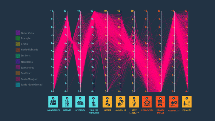
Equation and Scenarios
By means of the addition and implementation of a hierarchy system for the 11 factors, equations and scenarios can be established in accordance with the technical criteria of the user. To exemplify this process, we have made an analysis based on economy prioritizing population density, income and cadastral value factors. Graphs and diagrams are used to visualize and compare the results at various scales. In this case, it has been discovered that the Nou Barri and San Gervasi districts are in an entirely opposite situation in relation to their economic conditions. As a final step, the tool can generate a new cartography that shows key sites for development of projects and policies (Nou Barris district, the El Besos i el Maresme, El Poble Sec and El Raval neighborhoods). The neighborhood with the highest grade and, therefore, the most complicated economic situation is El Raval, located in the Ciudad Vella district. Validity for the tool is verified as it has found the same sites under different plans for emergency and prioritization of the city.
5. CSv. USER INTERFACE
In order to implement the tool, we propose the creation of a user interface to help decision-makers to gain full perspective of the social conditions of the population and territory. It also provides the population with better understanding of their environment and a place for comments on the areas where they live. This adds a new layer of data for the tool and helps the municipality, real estate agents, and consultants to truly consider the perspective of the citizens. The interface has the following elements:
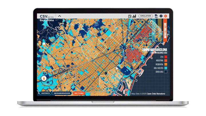
BCN Diagnostics: Users may pick from all the indicators used in the diagnostics of this research (social, economic and infrastructural). It is possible to visualize geospatial data on dynamic cartography with three scales: districts, neighborhoods and sections.
Data Visualization: Users may make comparative analyzes of the various conditions, districts, neighborhoods and census sections using the 11 normalized factors, graded from 1 to 10, as they were determined in this research as a basis to understand social land value. This visualization may take place in statistic graphs or tables.
Planning Data Equation: Users may focus on one of several available factors according to their own context or purpose, grading them from 1 to 5 and generating simulations to evaluate performance of all the neighborhoods and districts. The result may be visualized and analyzed in statistic graphs or tables alike.
Capturing Social Value: Users may generate their own dynamic cartography with the results of the proposed equation according to the factors hierarchy and find the best locations for urban planning, policies or projects. From touristic approaches to social-economic relations, the tool provides a great variety of options for its use.
Social participation: Users may create a profile, link social network accounts, complete surveys and overall create a first-hand database for the situation of the place where they live, ensuring that their voices are heard for implementation of plans, policies and projects.
It is a project of IAAC, Institute of Advanced Architecture of Catalonia.
Master in City and Technology, MACT 2019-2020.
Students: Byron Cadena, Pawitra Bureerak & Akshay Marsute.
Faculty: Luis Falcon.
Place: Barcelona, Spain